
Five things you need to know about El Niño’s likely comeback – Image for illustrative purposes only (Image credits: upload.wikimedia.org)
Sea surface temperatures across the equatorial Pacific hit 20.97°C in March, marking the second-highest reading ever for that month and hinting at brewing changes in the atmosphere-ocean dance.[1][2] Forecasters from agencies like NOAA now see a strong chance of El Niño developing as early as late spring, potentially strengthening through the year’s end. This shift arrives amid persistently elevated global ocean heat, raising questions about intensified weather patterns worldwide.
Forecasts Point to Onset Later This Year
Climate models have converged on a probable El Niño arrival, with NOAA’s Climate Prediction Center assigning a 61% chance for May through July, followed by persistence into late 2026.[3] The International Research Institute for Climate and Society offers an even higher estimate at 70% for April to June development.[2] Some projections suggest this event could rank among the more intense ones observed in recent decades.
These predictions stem from observations of warming waters in the central and eastern Pacific, where Niño indices show subtle upward trends. Neutral conditions dominate for now, but the trajectory favors a warm phase transition by fall. Uncertainty lingers over peak strength, as models vary in their intensity outlooks.
Current Conditions Remain Neutral
ENSO-neutral status prevails today, with the Niño-3.4 index hovering near -0.2°C in recent weeks.[3] This transitional phase likely holds through much of the summer, delaying any full El Niño declaration until September or later. Forecasters emphasize that no dramatic shifts have materialized yet, despite the warm backdrop.
Patience defines the monitoring process. All major centers agree on elevated odds for warming ahead, yet they caution against premature conclusions. This measured approach reflects the inherent variability in Pacific dynamics.
Natural Phenomenon, Amplified by Warming
El Niño forms part of the El Niño-Southern Oscillation, a recurring interplay between ocean temperatures and atmospheric circulation in the tropical Pacific. It stands apart from human-driven climate change as a natural cycle. However, when layered atop a greenhouse-warmed planet, its signals grow more pronounced.
The World Meteorological Organization highlighted this dynamic during the 2023-2024 episode: “during the last El Niño period (2023–2024), the combination of El Niño and climate change hit Latin America and the Caribbean with greater force, worsening droughts, heat waves, wildfires, extreme rainfall, and other impacts with significant human and economic costs.”[1] Global warming may also extend event durations beyond historical norms of nine to 18 months.
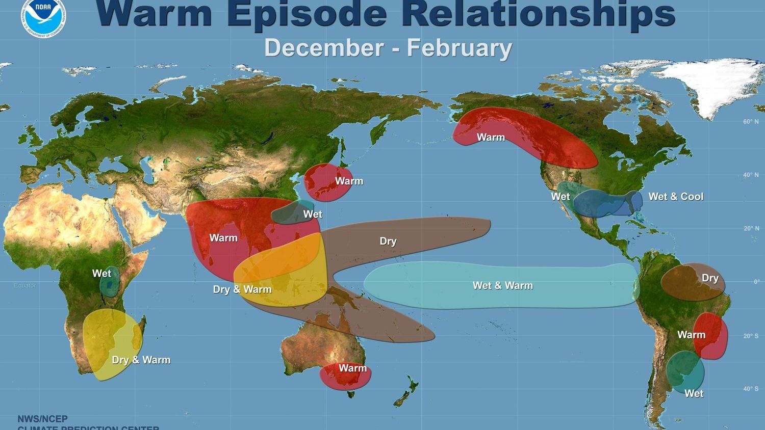
Teleconnections Reshape Weather Far Afield
Impacts ripple globally via atmospheric teleconnections, disrupting the Walker Circulation – a vast east-west flow of air and moisture. This leads to altered jet streams, pressure systems, and precipitation bands. In the U.S., southern regions often face wetter conditions and storms, while the north contends with relative dryness and warmth.
Atlantic hurricane activity typically dips, as shifted winds hinder storm formation. Still, other factors like local sea temperatures and high-pressure zones demand vigilance. Drought risks rise in vulnerable areas, compounding water stress from prior patterns. Heat waves intensify nearly everywhere El Niño touches.
- Southern U.S. and northern Mexico: Enhanced rainfall, storm potential.
- Northern U.S. and Canada: Warmer, drier winters; reduced snowpack.
- Atlantic basin: Fewer intense hurricanes overall.
- Latin America/Caribbean: Amplified extremes like floods and fires.
These patterns underscore the interconnected climate system, where Pacific warmth echoes across hemispheres.
Cycles Defy Predictable Timetables
El Niño episodes recur irregularly, every two to seven years on average every three to four. No rigid calendar governs their appearance, influenced by subtle oceanic cues. Recent spacing – following the strong 2023-2024 event – fits within observed variability, though quicker returns raise eyebrows amid ongoing ocean heat buildup.
Durations stretch from under a year to nearly two, with warming trends potentially prolonging them. Scientists track precursors like subsurface heat to refine timing, but surprises persist. This unpredictability challenges long-range planning yet drives ongoing research.
As models sharpen their gaze on fall 2026, communities from California to the Caribbean prepare for possible upheaval. Neutral conditions offer a brief respite, but the warming Pacific signals vigilance ahead. Understanding these cycles equips societies to navigate the extremes they unleash.