
A Bold White Contrast Emerges (Image Credits: Unsplash)
Southern Argentina – A sudden storm in early April 2026 transformed the typically arid plains east of the Andes into a striking white expanse.[1] Higher elevations received a fresh coating of snow, captured vividly by orbiting satellites just days into the southern hemisphere’s autumn. This rare display highlighted the region’s dramatic weather shifts and its unique glacial landscapes.
A Bold White Contrast Emerges
The Patagonian Desert, nestled on the eastern flank of the Andes, usually presents a dry, brown vista stretching toward the Atlantic Ocean. Glaciers carve colorful lakes into this otherwise barren terrain. Yet the early April storm delivered an unexpected winter preview, blanketing high plains with snow.[1]
Snow clung primarily to elevated areas, creating sharp boundaries with bare lower valleys. Strong winds played a key role, pushing precipitation from the Andes’ western slopes eastward. Atmospheric scientist René Garreaud of the Universidad de Chile observed that early fall brought above-average rainfall to southern Patagonia, based on satellite precipitation data.[1]
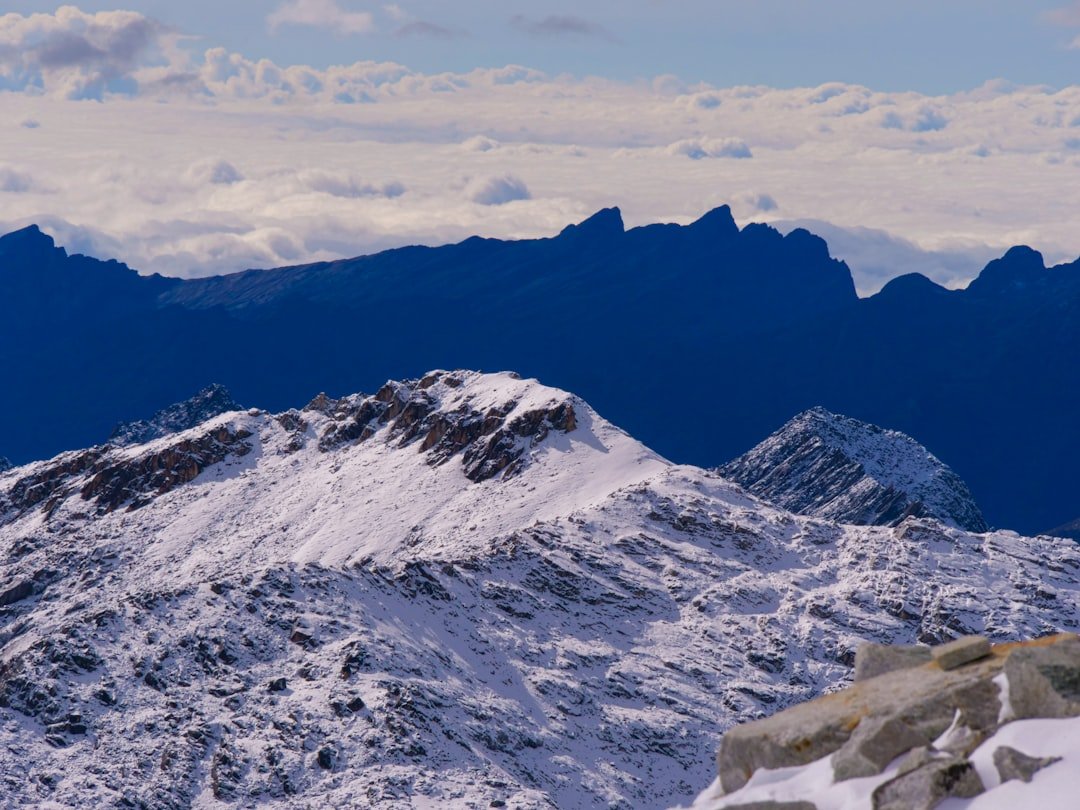
Satellites Offer Stunning Perspectives
NASA’s Terra satellite, equipped with the MODIS instrument, recorded the expansive snow cover on April 3, 2026. The image revealed vast white patches across the high plains, a fleeting alteration to the desert’s norm. Complementing this view, Landsat 9’s Operational Land Imager provided intricate details near Lago Argentino’s outlet.[1]
These observations underscored the event’s scale. Snow lines marked elevation thresholds precisely, while sediment-laden waters stood out in turquoise hues. Such satellite data aids scientists in tracking weather patterns and land changes in remote areas.
Winds Bridge the Andes’ Divide
Precipitation favors the Andes’ windward western side, where moist air rises and condenses. The region’s rain shadow leaves the east parched. However, powerful gusts transported snow across the divide during this storm.[1]
Garreaud noted, “Strong winds are capable of blowing some snow east into the Argentinian side, as beautifully reflected in the MODIS image.” Satellite estimates confirmed elevated moisture from late March into early April. This dynamic illustrates how atmospheric forces momentarily defy the desert’s aridity.
- Western Andes receive most regional rainfall due to orographic lift.
- Eastern plains form a classic rain shadow desert.
- Exceptional winds enable cross-mountain snow transport.
- Early 2026 season marked by surplus precipitation.
- Snow accumulation favored peaks above certain altitudes.
Turquoise Lakes Amid White Peaks
Lago Argentino and neighboring waters owe their vivid colors to glacial flour – fine rock particles ground by nearby ice fields. Suspended sediment scatters light, producing milky blue tones. The April 3 images showed these lakes contrasting sharply against snowy surroundings.[1]
Valleys draining these lakes remained snow-free, emphasizing elevation’s role. Southern Patagonia’s glaciers, abundant in areas like Los Glaciares National Park, continuously supply this sediment. The scene evoked the interplay between ice, water, and fleeting snow.
Snow’s Swift Retreat
The wintry spectacle proved short-lived. By the afternoon of April 4, 2026, satellite imagery indicated melting across most areas, save the loftiest peaks. Warm temperatures and sun rapidly erased the cover from plains and mid-elevations.[1]
This quick thaw aligns with Patagonia’s variable climate. Such events offer brief beauty while signaling seasonal transitions. Scientists value these glimpses for understanding moisture distribution and glacial influences. For more details, see the full analysis from NASA Earth Observatory.[1]
Key Takeaways
- An early April 2026 storm brought snow to arid eastern Patagonia, visible via NASA satellites.
- Winds carried flakes from the Andes’ wet west to the dry east.
- Glacial flour creates the lakes’ signature turquoise glow.
This ephemeral snow event reminds us of Patagonia’s delicate weather balance, where deserts meet ice. It underscores the value of satellite monitoring in capturing nature’s quick changes. What impacts do you see from such storms on local ecosystems? Share your thoughts in the comments.