
A Feature That Captivates from Above (Image Credits: Unsplash)
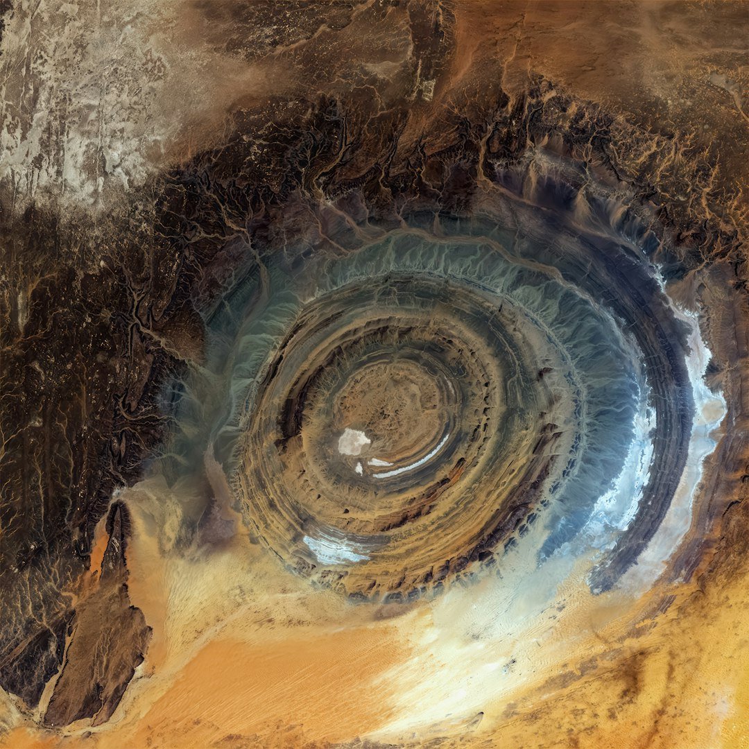
In the vast expanse of the Sahara, a remote plateau in northern Mauritania hosts one of Earth’s most distinctive geological features. The Richat Structure, often called the Eye of the Sahara, emerges as a series of concentric ridges spanning 40 kilometers across. Visible primarily from orbit, this formation has intrigued scientists and astronauts for decades.[1]
A Feature That Captivates from Above
Astronauts first drew widespread attention to the Richat Structure during the Gemini IV mission in 1965. Ed White and James McDivitt captured images that highlighted its bull’s-eye appearance against the desert landscape. From the ground, the feature blends into the terrain, but satellites reveal its full scale and symmetry.
Recent observations from Landsat 8 and 9 instruments underscored this visibility. Captured in early March 2026, the mosaic displayed orange and gray hues from varying rock compositions. Wind and ancient waters shaped the surrounding dunes and valleys, framing the structure dramatically.[1]
Human History Amid the Sands
The Adrar Plateau region preserved traces of early human activity. Paleolithic stone tools dotted the area, while Neolithic cave paintings adorned nearby shelters. Medieval caravan towns once thrived here, supporting trade routes across the desert.
These remnants contrasted with the dominant natural sculpting. Dark desert pavements capped plateaus, and networks of dry river channels marked past water flows. The Richat Structure stood as a silent backdrop to this layered history.
Unraveling Its Geological Origins
French geographers documented the feature in the 1930s, dubbing it the Richat “buttonhole.” Early assumptions pointed to a meteor impact due to its circular form. Subsequent studies revealed a different story: an uplifted dome over an igneous intrusion.
Erosion played the key role in its current shape. Differing rates among rock layers carved concentric cuestas, or ridges. Sedimentary and igneous materials produced the distinctive colors observed today. This process unfolded over millions of years, tied to Cretaceous alkaline activity.[1]
Scientific Evolution and Modern Insights
Researchers shifted from crater theory after detailed fieldwork. Studies confirmed the dome’s formation through uplift and erosion, not extraterrestrial impact. Geophysical models explored the underlying magmatic intrusion’s emplacement.
Recent papers dated the structure’s polyphase history. Publications in journals like Lithos and Arabian Journal of Geosciences provided kinematics details. These findings enhanced understanding of similar features worldwide.[1]
- 40 kilometers (25 miles) in diameter
- Concentric ridges from differential erosion
- Orange-gray palette from rock variations
- Cretaceous-era igneous roots
- Prominent in satellite imagery
- Linked to alkaline complex
Key Takeaways
- The Richat Structure formed as an eroded dome, not an impact crater.
- Astronaut photos popularized it as the Eye of the Sahara.
- Its ridges result from uplift and varied erosion rates.
The Richat Structure endures as a testament to Earth’s dynamic geology, blending natural forces with hints of human past. Ongoing research promises deeper revelations about such desert domes. What draws you to this Saharan wonder? Share your thoughts in the comments.