
Explosive Intensification Sets Records (Image Credits: Unsplash)
U.S. Northern Mariana Islands – A formidable super typhoon barreled toward remote Pacific territories this week, marking one of the strongest storms recorded so early in the typhoon season. Super Typhoon Sinlaku, with sustained winds reaching 175 miles per hour, approached Saipan, Tinian, and Rota, prompting urgent preparations among residents.[1] Heavy rains already lashed the islands as the storm’s outer bands made initial contact on April 14, 2026. Officials forecasted typhoon-force winds persisting through the following day.
Explosive Intensification Sets Records
Super Typhoon Sinlaku formed in early April over the western Pacific and underwent rapid strengthening, evolving from a tropical disturbance into a category 5 equivalent within days.[2] Meteorologists highlighted its exceptional power for mid-April, classifying it as a violent typhoon on the Japan Meteorological Agency scale.[1] This placed Sinlaku among the few such storms to achieve peak intensity so soon after the year’s start in the northwest Pacific basin.
The Joint Typhoon Warning Center tracked maximum sustained winds near 280 kilometers per hour as the system churned northwestward.[1] Warm sea surface temperatures exceeding 28 degrees Celsius fueled this acceleration, enabling the storm to rival global records for early-season ferocity.[3] By April 13, forecasters warned of catastrophic potential upon nearing land.
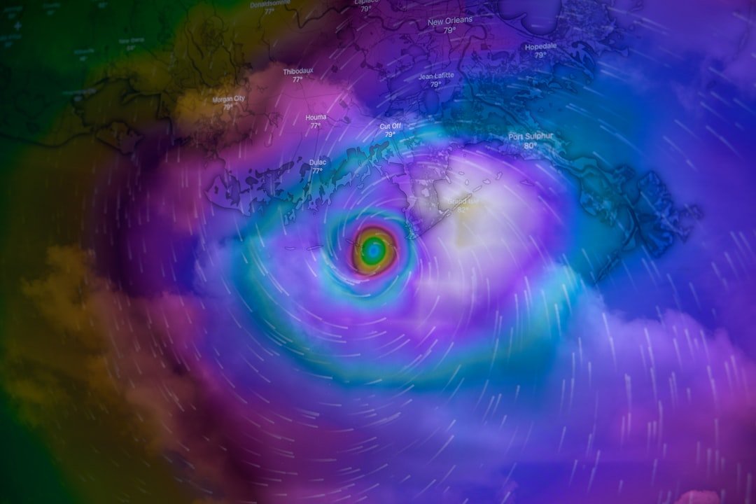
Satellite Eyes Capture the Storm’s Scale
Instruments aboard the Suomi NPP satellite provided a stark view of Sinlaku’s well-defined eye and expansive cloud shield on April 13.[1] The Visible Infrared Imaging Radiometer Suite recorded the scene at 03:30 Universal Time, revealing the typhoon’s structure amid the North Pacific.[1] Such observations underscored the storm’s compact yet devastating circulation.
National Weather Service updates confirmed outer rainbands delivering downpours to Saipan and nearby isles by morning on April 14. Conditions escalated as the core neared, with gusts surpassing 100 miles per hour in exposed areas.[4] Forecasts predicted a slight weakening before peak impact, yet dangers remained acute.
Threats to Vulnerable Territories
Residents of the U.S. territories faced a multi-hazard onslaught, including sustained typhoon winds, storm surge up to 15 feet, and flash flooding risks.[5] Saipan and Tinian braced for direct passage, while Guam positioned for indirect battering from swells and rains. Power outages and infrastructure strain loomed large in these isolated communities.
- Typhoon-force winds extending 50 miles from the center.
- Torrential rainfall totaling 15-25 inches in 24 hours.
- Hazardous surf generating life-threatening rip currents.
- Storm surge inundating low-lying coastal zones.
- Potential for landslides in rugged terrain.
Evacuations and shelter activations proceeded amid these projections. The event tested local resilience in a region prone to such tempests.
Gravity Waves and Broader Atmospheric Effects
Beyond surface devastation, Sinlaku generated high-altitude gravity waves detectable in the mesosphere.[1] Nighttime imagery from NOAA-20’s VIIRS instrument illuminated these concentric ripples via airglow, extending far above the troposphere. This phenomenon illustrated the storm’s profound influence on global atmospheric dynamics.
Sinlaku ranked as the second category 5 cyclone worldwide in 2026, trailing only Horacio from the South Indian Ocean in February. Such early powerhouses signal an active season ahead, with counterparts like Tropical Cyclone Maila and Vaianu active elsewhere.[1]
Key Takeaways
- Sinlaku achieved super typhoon status through rapid intensification over warm waters.
- Direct threats included extreme winds, surge, and flooding for Mariana Islands.
- Satellite data highlighted both surface fury and upper-atmosphere waves.
As Sinlaku transitioned from peak threat to post-impact recovery, its legacy underscored the Pacific’s unforgiving nature and the value of advanced monitoring. Communities in the Marianas demonstrated preparedness amid the onslaught, offering lessons for future resilience. What impacts did this storm have in your region, or how do you prepare for such events? Tell us in the comments.