


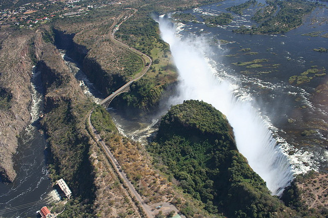
Few geographic features on Earth carry quite this much weight. A shallow chain of limestone shoals stretched between southern India and Sri Lanka has, for centuries, triggered arguments between geologists, mythologists, archaeologists, and politicians. What looks from orbit like a deliberate causeway has been explained as everything from divine engineering to the slow, indifferent work of tidal currents. Then, in 2024, new satellite data arrived, sharper and deeper than anything before, and the conversation started again.
Adam’s Bridge is a submerged ridge connecting India and Sri Lanka, generally regarded as a chain of shoals extending for roughly 29 km from Dhanushkodi on the Indian side to Talaimannar Island of Sri Lanka. The feature is 48 km long, separates the Gulf of Mannar from the Palk Strait, and in some regions is dry, with the sea rarely exceeding one metre in depth, making it extremely difficult for boats to pass over it. The structure’s odd geometry and near-perfect linearity have always been the fuel behind the controversy.
A Structure Known by Many Names

In most South Asian countries, this geographic extent is referred to as Ram Setu, with reference to the Hindu mythology of the Ramayana, while Persian navigators called it “Setu Bandhai,” meaning “bridge on the sea connecting India and Sri Lanka.” Major James Rennel, the Surveyor General of Bengal for the East India Company, labeled this geographic extent as Adam’s Bridge on all provincial maps, though many European navigators were already using that name by his time.
The name Adam’s Bridge appeared probably around the time of Al-Biruni around 1030, premised on the Islamic belief that Adam’s Peak, where the biblical Adam fell to earth, is located in Sri Lanka, and that Adam crossed over this formation. The naming history alone reveals how many different cultures have looked at the same strip of shallow water and seen something meaningful in it. Each tradition has its own explanation for why it is there.
The ISRO and NASA Breakthrough of 2024
Scientists from the Indian Space Research Organisation collaborated with NASA’s ICESat-2 satellite to produce the most comprehensive map of Adam’s Bridge ever created. Utilizing data from the ICESat-2 satellite collected between October 2018 and October 2023, researchers produced a detailed 10-meter resolution map, revealing the entire length of the underwater structure. This was a genuine step change in what science could see.
ICESat-2’s green laser enabled deeper seafloor penetration, detecting the seafloor up to 40 meters depth, and researchers collected approximately 0.2 million photons from the satellite to generate high-resolution bathymetric data at 10-meter resolution. Scientists from ISRO’s Jodhpur and Hyderabad National Remote Sensing Centre created a comprehensive image of the structure underwater using this advanced laser technology.
What the New Maps Actually Revealed
The volume of Adam’s Bridge computed in the ISRO research yielded approximately 1 cubic kilometre, with only 0.02 percent of this volume above mean sea level, meaning that around 99.98 percent of the structure is submerged in shallow and super-shallow waters. The sheer scale of what lies beneath the surface had never been measured with this precision before.
Led by ISRO scientist Giribabu Dandabathula, the research team identified 11 narrow passages essential for water flow between the Palk Strait and the Gulf of Mannar, which are crucial for preserving the bridge from sea waves. The results confirmed that, in its entirety, Adam’s Bridge is a submarine continuation of Dhanushkodi and Talaimannar Island, with approximately 1.5 km on either side of the crest line being highly undulating within super-shallow water with occurrences of sudden depths.
The Geology: What Science Currently Says
Multiple theories exist regarding the formation of the bridge. One theory suggests that the Palk Strait and the Gulf of Mannar were once part of the Kaveri River basin, and due to long-term tectonic movements the outline of the region formed. The particular shapes of these landforms contributed to coral growth, and the coral trapped sand, producing the discontinuous shoreline that is now called Adam’s Bridge.
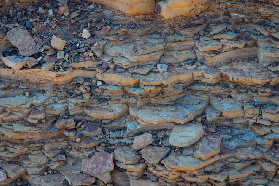
Studies on material strata through historical borings yielded sand up to a depth of 7 to 9 metres, and further depths yielded Holocene conglomerate, beds of limestone, calcareous sandstone, and occasional corals, followed by a layer of sand and then hard rocks or continuous compact formation. The Geological Survey of India has dated the coral at Rameswaram Island to 125,000 years ago, and the sea level in the region is believed to have oscillated significantly, with sand deposits possibly forming during periods of low sea level when the bridge was exposed.
The Age Problem: Why the Rock Layers Confuse Everyone
Some researchers have cast doubt on the naturalness of Ram Setu. Studies suggest that the rocks making up the bridge are about 7,000 years old, while the sand formations beneath them are much younger, leading some researchers to suggest the rocks could have been deliberately placed there by some ancient civilization. This inverted stratigraphy is the main argument made by those who believe the structure was artificially constructed.
Dr. Badrinarayanan, a former director of the Geological Survey of India, studied the seabed and found that borehole samples indicated loose sand layers beneath solid rock formations, which in natural formations would be rare. He surmised this strengthened arguments that Ram Setu was created or altered in antiquity. The lack of comprehensive field studies explains many of the uncertainties, as the structure mostly consists of a series of parallel ledges of sandstone and conglomerates that are hard at the surface and grow coarse and soft as they descend to sandy banks.
What NASA Actually Said About the Images
NASA said that its satellite photos had been egregiously misinterpreted during protests against the Sethusamudram Shipping Canal Project, stating that the images reproduced on websites may well be theirs, but their interpretation was certainly not, and that remote sensing images or photographs from orbit cannot provide direct information about the origin or age of a chain of islands, and certainly cannot determine whether humans were involved in producing any patterns seen.
In 2003, space-based investigations using satellite remote sensing imagery by the Space Applications Centre in Ahmedabad concluded that Ram Setu is not man-made. A report from the Archaeological Survey of India found no evidence for the structure being anything but a natural formation, and the Archaeological Survey and the government of India informed the Supreme Court in a 2007 affidavit that there was no historical proof of the bridge being built by Rama. The scientific consensus, while not unanimous, leans decisively toward natural formation.
The Sea Level Story: A Former Land Connection
Due to lowered sea levels during the Last Glacial Period, which lasted from approximately 115,000 to 11,700 years before present, sea levels reached a maximum of 120 metres below present values, meaning the relatively shallow Palk Strait was exposed as dry land connecting the Indian subcontinent and Sri Lanka. Following the rise to present sea levels during the Holocene, by around 7,000 years ago the strait became submerged.
The islands of Adam’s Bridge became emergent again following sea level falls in the region from around 5,000 years ago to the present. Temple records from Rameswaram indicate that the bridge remained above sea level until 1480, when it was significantly damaged by a powerful storm. This documented submergence gives the debate a real historical anchor, one that is independent of mythology.
The Ramayana Connection: Faith and Evidence
The ancient Sanskrit epic Ramayana, in the Yuddhakanda, mentions a bridge constructed by the god Rama with the aid of an army of Vanaras to reach the island Lanka and rescue his wife Sita from Ravana. A 2026 study published in the journal Geoheritage identified Ram Setu as a chain of sandbanks, coral deposits, and limestone shoals primarily formed through natural coastal processes, but acknowledged possible traces of human modification.
Revered in the Ramayana as a divine bridge constructed by Lord Rama and his Vanara army, the structure occupies a unique position at the intersection of mythology, culture, and geoscience. Beyond its physical formation, the bridge endures as a potent cultural and spiritual symbol representing divine intervention, moral victory, and the integration of mythic memory with landscape. Science and belief have not found a shared language here, and the 2024 mapping data has not settled that tension.
The Political Dimension: A Bridge Built From Votes

Adam’s Bridge represents not only a topic of scientific and religious controversy but also a source of political dispute. The bridge has become highly politicized in India, especially in the context of political parties seeking the electoral votes of Hindu voters. In 2005, the government of India approved a multi-million dollar Sethusamudram Shipping Canal Project that aimed to create a ship channel across the Palk Strait by dredging the shallow ocean floor near Dhanushkodi, a channel expected to cut over 400 km off the voyage around Sri Lanka, with its alignment requiring dredging through Adam’s Bridge.
A government-commissioned committee released a 2013 report calling the project “unviable both from the economic as well as ecological angles,” yet the Indian government rejected the report and decided to proceed in its current form. Critics have argued that the project could disrupt marine ecosystems, increase coastal erosion, and seriously harm local fishing communities. The science has become inseparable from the politics, a pattern that shows no sign of easing.
The Ecological Stakes: More Than a Geological Debate

Research affirms Ram Setu as both a natural heritage site and a living cultural monument, emphasizing its ecological importance within the Gulf of Mannar Biosphere Reserve. The Marine and Water Resources Group of ISRO’s Space Applications Centre concludes that Adam’s Bridge comprises 103 small patch reefs. These reefs are active ecosystems, not just geological artifacts.
The structure is currently in a zone of active wave attacks from both the Gulf of Mannar and the Palk Strait, and its current form is significantly influenced by sedimentation and sand movements, patterns of currents, and wave energy, which have resulted in maintaining asymmetrical slopes on either side and the aggregation of sand deposits on its crest and sides. The 2024 ISRO study provides valuable data for future research in marine geophysics and archaeology, enhancing understanding of both geological history and cultural significance. Whatever the origin, the ecosystem around it is real and fragile.
Where the Evidence Actually Stands in 2026

A 2026 geomythology study published in Geoheritage adopted a descriptive-analytical methodology, integrating field investigations, geospatial analyses, and documentary reviews, while ancient literary sources including the Ramayana, Mahabharata, and Skanda Purana were critically analysed alongside contemporary geological surveys and geophysical datasets. The study positioned Ram Setu as a vital confluence of natural heritage, cultural identity, and environmental stewardship, demonstrating how geomythology can attempt to reconcile scientific observation with traditional belief.
To date, geological studies around Adam’s Bridge remain limited, except for a constrained geomorphological observation made by the Marine Wing of the Geological Survey of India and a seismic survey by the National Institute of Oceanography. Those claiming Adam’s Bridge was constructed have based their arguments on vague speculation and the reasonable point that not every detail of its formation has been incontrovertibly settled, while Indian geologist C. P. Rajendran described the media controversy as an “abhorrent” example of the post-truth era. The most honest position right now is that the new satellite data has deepened the picture of this structure without resolving who or what built it.
The debate over Adam’s Bridge is, in a sense, a mirror for how humans approach the unknown. The same shallow shoals become proof of a divine miracle, a natural geological accident, or a lost ancient civilization depending entirely on what the observer brings to the question. The 2024 ISRO and NASA maps offered the most precise look ever at what lies beneath the water, and what they found was breathtaking in its detail. The question of origin, though, remains exactly where it was before: genuinely open, technically unanswered, and charged with meaning that goes far beyond any satellite image.